
Eastern Crete , nearby Kalavros
Αξιοθέατα
Vai, or more specifically the palm forest of Vai, is one of the most popular sights in Crete and one of the most beautiful and special places in the whole of the Mediterranean. Vai draws a lot of visitors each year from all over Crete. They come not only for its wonderful palm forest, but also for the large sandy beach spread out at its foot. The beach is fully organised, with sun loungers, straw umbrellas and wooden walkways for easy access. At the side of the beach, near the steps to the viewing platform, is a good restaurant and a cafeteria with chairs and tables set out in a pretty, flat space among the palm trees.
94 lokal ang nagrerekomenda
Vai Beach
Eparchiaki Odos Monis Toplous - VaiVai, or more specifically the palm forest of Vai, is one of the most popular sights in Crete and one of the most beautiful and special places in the whole of the Mediterranean. Vai draws a lot of visitors each year from all over Crete. They come not only for its wonderful palm forest, but also for the large sandy beach spread out at its foot. The beach is fully organised, with sun loungers, straw umbrellas and wooden walkways for easy access. At the side of the beach, near the steps to the viewing platform, is a good restaurant and a cafeteria with chairs and tables set out in a pretty, flat space among the palm trees.
The fall of Richtis
The gorge of Richtis is located in Lasithi Prefecture, on the north side of Crete, between the cities Agios Nikolaos and Sitia. The trail starts just outside the village Exo Mouliana and ends on the Richtis beach, east of the village Kalavros. The total length of the route is approximately 3 kilometers and the elevation difference between the starting point and the beach is about 350 meters. The gorge, even in summer, has enough water, which is used for local crops. The gorge collects the water from the peak Drymias (918m) of Orno range through the streams of Lachanas and Mesa Mouliana which merge near the starting point.
Hiking to the beach takes approximately three to four hours, depending on the hiking pace. The route starts from the stone-arched bridge of Lachanas (19th century) where, during the exchange of populations between Greece and Turkey, it is said that the Christians killed the Turks of the region, who were trying to reach Sitia and get the ship to Turkey.
The route continues in a lush landscape along the river, within an amazing scenery of East Crete. Platans, oleander and sage are everywhere and the smells of fresh herbs change constantly. Impressive also - footprint of the past - is the old water mills that the visitors meet in the path.
The highlight of the gorge is, however, the beautiful waterfall Richtis with a height exceeding 20 meters and the smal pond formed below it (richtis means waterfall in the Cretan dialect). The waterfall has water even in summer and is a great place to have a refreshing dive. The path ends in the beautiful pebbly beach of Richtis. The beach has a small park with tamarisk trees, with stone seats and tables around and water fountain with potable water.
Attention: Please avoid using sunscreen protection if you swim in rivers, as it destroys the fragile flora and fauna of the stream.
Tip: Most visitors leave their car in the central road at Exo Mouliana and walk down the paved road to meet the bridge Lahanas. You can gain around 30' minutes of walk if you drive and park next to the bridge of Lahanas; from there reaching the waterfall takes around 1.5-2 hours. However, for less able-bodied people or people with young children, the shortest way to reach the waterfall is to drive in the narrow paved road to the beach of Richtis and walk for around 30' in the opposite direction of the river.
63 lokal ang nagrerekomenda
Richtis Gorge
The fall of Richtis
The gorge of Richtis is located in Lasithi Prefecture, on the north side of Crete, between the cities Agios Nikolaos and Sitia. The trail starts just outside the village Exo Mouliana and ends on the Richtis beach, east of the village Kalavros. The total length of the route is approximately 3 kilometers and the elevation difference between the starting point and the beach is about 350 meters. The gorge, even in summer, has enough water, which is used for local crops. The gorge collects the water from the peak Drymias (918m) of Orno range through the streams of Lachanas and Mesa Mouliana which merge near the starting point.
Hiking to the beach takes approximately three to four hours, depending on the hiking pace. The route starts from the stone-arched bridge of Lachanas (19th century) where, during the exchange of populations between Greece and Turkey, it is said that the Christians killed the Turks of the region, who were trying to reach Sitia and get the ship to Turkey.
The route continues in a lush landscape along the river, within an amazing scenery of East Crete. Platans, oleander and sage are everywhere and the smells of fresh herbs change constantly. Impressive also - footprint of the past - is the old water mills that the visitors meet in the path.
The highlight of the gorge is, however, the beautiful waterfall Richtis with a height exceeding 20 meters and the smal pond formed below it (richtis means waterfall in the Cretan dialect). The waterfall has water even in summer and is a great place to have a refreshing dive. The path ends in the beautiful pebbly beach of Richtis. The beach has a small park with tamarisk trees, with stone seats and tables around and water fountain with potable water.
Attention: Please avoid using sunscreen protection if you swim in rivers, as it destroys the fragile flora and fauna of the stream.
Tip: Most visitors leave their car in the central road at Exo Mouliana and walk down the paved road to meet the bridge Lahanas. You can gain around 30' minutes of walk if you drive and park next to the bridge of Lahanas; from there reaching the waterfall takes around 1.5-2 hours. However, for less able-bodied people or people with young children, the shortest way to reach the waterfall is to drive in the narrow paved road to the beach of Richtis and walk for around 30' in the opposite direction of the river.
The impressive cave of Zeus, the Diktaean Cave, is located above the village Psychro in Lassithi Plateau at an altitude of 1025m. In Psychro there is plenty of parking space, with plenty of restaurants nearby. Two paths leading to the cave start from the parking area. The easiest path is the left one, because in the right path (the oldest) the stones are worn by thousands of tourists and are slippery. The route to the cave is magnificent as the view to the Lassithi Plateau is breathtaking. If you do not want to walk, there are donkeys for transfering the visitors to the cave. Near the entrance of the cave there is a kiosk where you can buy tickets for a small price. The cave, which has an area of 2200 sq.m, is well lit and the paths in it come along a well-designed path of 250m length.
Near the entrance, on the right there is a hall, while the great hall starts at a lower level. Southeast of the chamber there is a large stalagmite complex. Also, there are some buildings. A smaller hall is located on the northwest side. While moving inside the cave, the visitor enters the great hall with the largest part of it being covered by solid rock and large stalagmites. In the second part of the cave, there is a large and very spectacular stalactite, called as the “mantle of Zeus”. Unfortunately, this stalagmite has been damaged by visitors. The entire great hall has impressive decor with large columns, stalactites and stalagmites.
63 lokal ang nagrerekomenda
Kweba ni Zeus
The impressive cave of Zeus, the Diktaean Cave, is located above the village Psychro in Lassithi Plateau at an altitude of 1025m. In Psychro there is plenty of parking space, with plenty of restaurants nearby. Two paths leading to the cave start from the parking area. The easiest path is the left one, because in the right path (the oldest) the stones are worn by thousands of tourists and are slippery. The route to the cave is magnificent as the view to the Lassithi Plateau is breathtaking. If you do not want to walk, there are donkeys for transfering the visitors to the cave. Near the entrance of the cave there is a kiosk where you can buy tickets for a small price. The cave, which has an area of 2200 sq.m, is well lit and the paths in it come along a well-designed path of 250m length.
Near the entrance, on the right there is a hall, while the great hall starts at a lower level. Southeast of the chamber there is a large stalagmite complex. Also, there are some buildings. A smaller hall is located on the northwest side. While moving inside the cave, the visitor enters the great hall with the largest part of it being covered by solid rock and large stalagmites. In the second part of the cave, there is a large and very spectacular stalactite, called as the “mantle of Zeus”. Unfortunately, this stalagmite has been damaged by visitors. The entire great hall has impressive decor with large columns, stalactites and stalagmites.
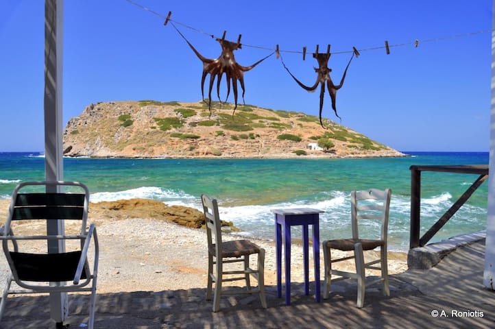
The thousands of visitors arriving daily with the boat from Ierapetra to Chrissi island mainly swim on the beach of Belerinina or Golden Beach. Bright blue water, white sand with pink shades from the thousands of broken shells, the junipers that hold the sand with their huge roots is the backdrop that makes anyone fall in love with this place.
The island can be accessed from Ierapetra by ferry and the trip lasts about 50 minutes. The boats stop at the south side of the island and to get to Belegrina you have to cross the juniper wood to the north side of the island for about 10 minutes. Collecting shells, sand and anything else on the island is strictly forbidden, and great care is needed not to break branches from the protected junipers. The beach is initially rocky and then turns sandy.
8 lokal ang nagrerekomenda
Belegrina Beach
The thousands of visitors arriving daily with the boat from Ierapetra to Chrissi island mainly swim on the beach of Belerinina or Golden Beach. Bright blue water, white sand with pink shades from the thousands of broken shells, the junipers that hold the sand with their huge roots is the backdrop that makes anyone fall in love with this place.
The island can be accessed from Ierapetra by ferry and the trip lasts about 50 minutes. The boats stop at the south side of the island and to get to Belegrina you have to cross the juniper wood to the north side of the island for about 10 minutes. Collecting shells, sand and anything else on the island is strictly forbidden, and great care is needed not to break branches from the protected junipers. The beach is initially rocky and then turns sandy.
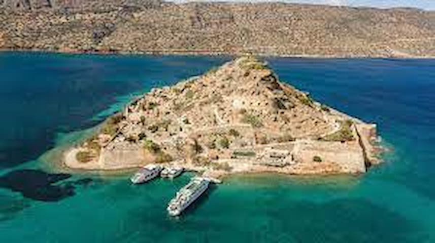
Spinalonga is a small island located at the entrance of Elounda lagoon and north of the Gulf of Mirabello. It has an area of 85 acres and its maximum height is 53 meters.
During the Cretan War (1645-1669) refugees and rebels (Chainides) used the island as a refuge and a base for bothering Turks. Their presence lasted as long as the Venetians held the fort. After the Fall of Candia in 1669, Spinalonga remained under the control of Venice. The Venetians tried to keep the strategic fort, with the fortresses of Imeri Gramvousa and Souda, hoping to get back the island of Crete in future.
However, in 1715, the Turks came to terms with the Venetians and occupied the island. During the first years of Ottoman occupation, the fortress was marginalized and used as a place of exile and isolation. Later, a purely Ottoman settlement gradually formed in Spinalonga, since the island provided absolute security for families. In the late 19th century, the role of the port of Spinalonga was upgraded, since it obtained a license for export trade. In the mid-19th century the island gathered a large number of residents, mostly merchants and sailors, who took advantage of the license. It is estimated that in 1834, 80 families lived in the castle of Spinalonga, while in 1881 this number rose to 227. Even today there are buildings from the period of the castle town, as two-storey houses with tall yard walls and shops with wide doors and large windows.
The life of this settlement stopped abruptly because of the political changes that took place in Crete during the last years of the 19th century. In 1897, French military forces were installed on the island for about one year.
The uncertainty that prevailed among the Ottomans in Crete, because of the revolutionary actions of Christians, forced most residents of Spinalonga to migrate. Until 1903, all Turks abandoned the island.
THE LEPER COLONY
In 1903, the Cretan State gathered all lepers who lived in settlements near the major cities of Crete, called Meskinia, and moved them to Spinalonga. Thus, the island became a leper colony for the Cretan patients of Hansen's disease, known as leprosy. Initially, lepers were brought from Crete and, later, from all over Greece.
A story full of pain, screams and death would conquer the island for half a century. Initially the lives of lepers were miserable. Spinalonga was a vast slum, a cemetery for lepers, without any organization, without medication for the sicks, without hope.
Later, Leper Hospital upgraded. It had a director, a doctor, nurses, caretakers, cleaners, financial service and priest. The lepers resided in the Turkish community houses and in modern buildings constructed in the 30s. Large parts of the Venetian walls were destroyed in 1939, with dynamite, in order to open up the perimeter road that currently exists on the islet. After the establishment of the leper colony, residents from the opposite coast, built the present village of Plaka, just opposite Spinalonga, so as to serve the leper colony.
During the Italian-German occupation, the occupiers did not dare to release the lepers, and were forced to take care of them, since the opposite village of Plaka was evacuated. Also, the whole coastal area of Elounda had been fortified with machine guns, underground mines, firearms, etc, since German feared a possible invasion of the British in that area. None Italian or German dared to enter the colony. This fact helped lepers to operate illegal radio, while the doctor Grammatikakis copied the news from London and Cairo and shared this to residents.
Finally, in 1957, with the discovery of antibiotics and after all lepers were cured, the leper colony closed and the island was deserted. The last inhabitant, a priest, left the island in 1962. This was to maintain the religious tradition of the Greek Orthodox Church, in which buried persons have to be commemorated 40 days, 6 months, 1, 3 and 5 years after their death.
After 1957 and for several decades, the island remained abandoned. With the raised interest of many tourists, the local authorities started in 70s to systematically repair and renovate old buildings, fortifications of the Venetian walls, old houses and roads, and tore the buildings of the hospital down. Since then, works for improving the condition of buildings on Spinalonga, have never stopped.
Today the castle and the castle of Spinalonga is preserved, in its most part, in good condition and the island is considered one of most important remaining strongholds in the Mediterranean sea.
Over 300,000 visitors each year visit this charming island by boat, starting from Agios Nikolaos, Elounda and Plaka, which is just 800 meters away. This number brings the island in the first five Byzantine / post-Byzantine archaeological sites in Greece.
In 2005, the author Victoria Hislop wrote a gripping novel about Spinalonga, titled "The Island", which won the British Book Award of Newcomer of the Year 2007. The book has dominated for 24 weeks in the British top 10 and has been translated into over 15 languages, making Spinalonga and its history known throughout the world.
99 lokal ang nagrerekomenda
Nisida Spinalonga
Spinalonga is a small island located at the entrance of Elounda lagoon and north of the Gulf of Mirabello. It has an area of 85 acres and its maximum height is 53 meters.
During the Cretan War (1645-1669) refugees and rebels (Chainides) used the island as a refuge and a base for bothering Turks. Their presence lasted as long as the Venetians held the fort. After the Fall of Candia in 1669, Spinalonga remained under the control of Venice. The Venetians tried to keep the strategic fort, with the fortresses of Imeri Gramvousa and Souda, hoping to get back the island of Crete in future.
However, in 1715, the Turks came to terms with the Venetians and occupied the island. During the first years of Ottoman occupation, the fortress was marginalized and used as a place of exile and isolation. Later, a purely Ottoman settlement gradually formed in Spinalonga, since the island provided absolute security for families. In the late 19th century, the role of the port of Spinalonga was upgraded, since it obtained a license for export trade. In the mid-19th century the island gathered a large number of residents, mostly merchants and sailors, who took advantage of the license. It is estimated that in 1834, 80 families lived in the castle of Spinalonga, while in 1881 this number rose to 227. Even today there are buildings from the period of the castle town, as two-storey houses with tall yard walls and shops with wide doors and large windows.
The life of this settlement stopped abruptly because of the political changes that took place in Crete during the last years of the 19th century. In 1897, French military forces were installed on the island for about one year.
The uncertainty that prevailed among the Ottomans in Crete, because of the revolutionary actions of Christians, forced most residents of Spinalonga to migrate. Until 1903, all Turks abandoned the island.
THE LEPER COLONY
In 1903, the Cretan State gathered all lepers who lived in settlements near the major cities of Crete, called Meskinia, and moved them to Spinalonga. Thus, the island became a leper colony for the Cretan patients of Hansen's disease, known as leprosy. Initially, lepers were brought from Crete and, later, from all over Greece.
A story full of pain, screams and death would conquer the island for half a century. Initially the lives of lepers were miserable. Spinalonga was a vast slum, a cemetery for lepers, without any organization, without medication for the sicks, without hope.
Later, Leper Hospital upgraded. It had a director, a doctor, nurses, caretakers, cleaners, financial service and priest. The lepers resided in the Turkish community houses and in modern buildings constructed in the 30s. Large parts of the Venetian walls were destroyed in 1939, with dynamite, in order to open up the perimeter road that currently exists on the islet. After the establishment of the leper colony, residents from the opposite coast, built the present village of Plaka, just opposite Spinalonga, so as to serve the leper colony.
During the Italian-German occupation, the occupiers did not dare to release the lepers, and were forced to take care of them, since the opposite village of Plaka was evacuated. Also, the whole coastal area of Elounda had been fortified with machine guns, underground mines, firearms, etc, since German feared a possible invasion of the British in that area. None Italian or German dared to enter the colony. This fact helped lepers to operate illegal radio, while the doctor Grammatikakis copied the news from London and Cairo and shared this to residents.
Finally, in 1957, with the discovery of antibiotics and after all lepers were cured, the leper colony closed and the island was deserted. The last inhabitant, a priest, left the island in 1962. This was to maintain the religious tradition of the Greek Orthodox Church, in which buried persons have to be commemorated 40 days, 6 months, 1, 3 and 5 years after their death.
After 1957 and for several decades, the island remained abandoned. With the raised interest of many tourists, the local authorities started in 70s to systematically repair and renovate old buildings, fortifications of the Venetian walls, old houses and roads, and tore the buildings of the hospital down. Since then, works for improving the condition of buildings on Spinalonga, have never stopped.
Today the castle and the castle of Spinalonga is preserved, in its most part, in good condition and the island is considered one of most important remaining strongholds in the Mediterranean sea.
Over 300,000 visitors each year visit this charming island by boat, starting from Agios Nikolaos, Elounda and Plaka, which is just 800 meters away. This number brings the island in the first five Byzantine / post-Byzantine archaeological sites in Greece.
In 2005, the author Victoria Hislop wrote a gripping novel about Spinalonga, titled "The Island", which won the British Book Award of Newcomer of the Year 2007. The book has dominated for 24 weeks in the British top 10 and has been translated into over 15 languages, making Spinalonga and its history known throughout the world.
Toplou Monastery is located in the northeastern tip of Crete, at the base of Sidero Cape, 10km east of Sitia and 6km north of Palekastro. The monastery is one of the most historic monasteries of Crete and is known for its vast real property. In religious circles it is known as the Monastery of Panagia Akrotiriani, while the locals just call it the Great Monastery.
It is worth visiting Toplou, even if it located 2.5 hours from Heraklion, since you can combine the visit with the beautiful beaches of the area, the site of ancient Itanos and the famous palm grove of Vai. The area is the one of the most arid and inhospitable places on Crete, while the constant strong winds have attracted one of the first wind farms on the island.
The monastery is fortified with a 10m high wall, which protected it from enemy attacks. It spans a square area of 800 square meters and has three floors, with 40 rooms, a 33m high bell tower. According to the tradition, it has 100 doors, but only 99 of them have been found. In the center of the monastery, there is a well with water, which ensured the monks during the various sieges by the Turks and the pirates. Opposite the well there is a two-aisled basilica dedicated to the Virgin Mary and John the Theologian.
The entrance is on the west side of the fort and its sturdy door was rolled on wheels. Above the main entrance there is still the hole called "killer", from where the monks threw stones or boiling hot liquids to anyone attempting to breach the door.
At the entrance of the main temple there is the inscription of 132BC of the "Arbitration of Magnets", which refers to the friction of ancient Itanos and Ierapytna, found in the ruins of the (near) ancient Itanos. The dispute concerned the island of Lefki (current Koufonissi), which was an important production center of the red dye, known as purple, and the island was eventually owned by Itanos.
The monastery stores some great and very old icons, such the Jesus Lord of John Kornaros (1770), the Unwithering Rose (1771), Santa Anastasia and Virgin Mary (which was found in a nearby cave where holy water flows). Moreover, there are several well-preserved frescoes dating back in the 14th century. Besides the icons, the monastery operates a museum with several old and historical religious objects, such as bibles, crosses, archbishops, sultan decrees, seals, revolutionary flags, etc.
The monastery celebrates on September 26, when a big fest takes place with pilgrims arriving from all over Greece. Toplou is open for the public daily, from 9:00 to 13:00 and from 14:00 to 18:00. Lastly, the monks produce and sell excellent products as organic wine, olive oil and raki.
TIMELINE
14th Century: A small temple in the closeby cave Agioneri is founded and a small monastery is built around it.
1498: Pirates destroy the monastery.
16th Century: Monks rebuild the monastery and acquire great wealth and real property in the area. It also appends poorest and smaller monasteries, such as the monastery of Kapsas.
1530: The Genoese count of Malta, Henry Pescatore, destroys the old monastery. A new one is then built and gets equipped with a cannon. Indeed, Toplou acquires its name from the Turkish word top, meaning canon.
June 1821: The janissary Ibrahim Afentakis, after the massacre of 300 Christians in Tourtouli, slaughters the 12 monks the monastery. The monastery is deserted again.
1612: A strong earthquake causes major damages and the old buildings are torn down. A new one is built with a new strong wall, at the expense of the Venetians who tried then to promote Christianity in Crete so as to look friendly to the Cretans, especially compared to the emerging Muslim enemy, the Turks. The monastery then, actually takes its current form.
1639: The monastery has 40 monks
1704: Toplou is declared as Stavropegic, i.e. under the direct protection of the Ecumenical Patriarch in Constantinople.
1798: Under the threat of confiscation of the monastery’s property by the Turks, Patriarch Gregory V, declares the property of the monastery as unconquered and undisturbed, thus he prohibits any alienation by the Turks without the authority of the Ecumenical Patriarch.
1821: The Turks slaughter the monks of the monastery, the monastery gets deserted and its treasure is looted.
December 1827: The Turks of Sitia find shelter in Toplou. After siege, they surrender. 12 of them are slaughtered and the rest are transferred to Halki Island, near Rhodes.
1828: Toplou is re-inhabited by monks
1866-69: The Turks destroy the monastery in retaliation for the involvement of the monk Melchizedek Michelidakis in the Revolutionary Committee of Sitia.
1870: A school starts operating inside the monastery
1941: During the German occupation of Crete, a radio station is setup for communication with the Allies in Cairo and some allies hide here. The Germans find it out and arrest the allies, the abbot and the monks of Toplou and execute them in the prisons of Agia (near Chania). The monastery's property gets confiscated.
61 lokal ang nagrerekomenda
Monasteryo ng Toplou
Toplou Monastery is located in the northeastern tip of Crete, at the base of Sidero Cape, 10km east of Sitia and 6km north of Palekastro. The monastery is one of the most historic monasteries of Crete and is known for its vast real property. In religious circles it is known as the Monastery of Panagia Akrotiriani, while the locals just call it the Great Monastery.
It is worth visiting Toplou, even if it located 2.5 hours from Heraklion, since you can combine the visit with the beautiful beaches of the area, the site of ancient Itanos and the famous palm grove of Vai. The area is the one of the most arid and inhospitable places on Crete, while the constant strong winds have attracted one of the first wind farms on the island.
The monastery is fortified with a 10m high wall, which protected it from enemy attacks. It spans a square area of 800 square meters and has three floors, with 40 rooms, a 33m high bell tower. According to the tradition, it has 100 doors, but only 99 of them have been found. In the center of the monastery, there is a well with water, which ensured the monks during the various sieges by the Turks and the pirates. Opposite the well there is a two-aisled basilica dedicated to the Virgin Mary and John the Theologian.
The entrance is on the west side of the fort and its sturdy door was rolled on wheels. Above the main entrance there is still the hole called "killer", from where the monks threw stones or boiling hot liquids to anyone attempting to breach the door.
At the entrance of the main temple there is the inscription of 132BC of the "Arbitration of Magnets", which refers to the friction of ancient Itanos and Ierapytna, found in the ruins of the (near) ancient Itanos. The dispute concerned the island of Lefki (current Koufonissi), which was an important production center of the red dye, known as purple, and the island was eventually owned by Itanos.
The monastery stores some great and very old icons, such the Jesus Lord of John Kornaros (1770), the Unwithering Rose (1771), Santa Anastasia and Virgin Mary (which was found in a nearby cave where holy water flows). Moreover, there are several well-preserved frescoes dating back in the 14th century. Besides the icons, the monastery operates a museum with several old and historical religious objects, such as bibles, crosses, archbishops, sultan decrees, seals, revolutionary flags, etc.
The monastery celebrates on September 26, when a big fest takes place with pilgrims arriving from all over Greece. Toplou is open for the public daily, from 9:00 to 13:00 and from 14:00 to 18:00. Lastly, the monks produce and sell excellent products as organic wine, olive oil and raki.
TIMELINE
14th Century: A small temple in the closeby cave Agioneri is founded and a small monastery is built around it.
1498: Pirates destroy the monastery.
16th Century: Monks rebuild the monastery and acquire great wealth and real property in the area. It also appends poorest and smaller monasteries, such as the monastery of Kapsas.
1530: The Genoese count of Malta, Henry Pescatore, destroys the old monastery. A new one is then built and gets equipped with a cannon. Indeed, Toplou acquires its name from the Turkish word top, meaning canon.
June 1821: The janissary Ibrahim Afentakis, after the massacre of 300 Christians in Tourtouli, slaughters the 12 monks the monastery. The monastery is deserted again.
1612: A strong earthquake causes major damages and the old buildings are torn down. A new one is built with a new strong wall, at the expense of the Venetians who tried then to promote Christianity in Crete so as to look friendly to the Cretans, especially compared to the emerging Muslim enemy, the Turks. The monastery then, actually takes its current form.
1639: The monastery has 40 monks
1704: Toplou is declared as Stavropegic, i.e. under the direct protection of the Ecumenical Patriarch in Constantinople.
1798: Under the threat of confiscation of the monastery’s property by the Turks, Patriarch Gregory V, declares the property of the monastery as unconquered and undisturbed, thus he prohibits any alienation by the Turks without the authority of the Ecumenical Patriarch.
1821: The Turks slaughter the monks of the monastery, the monastery gets deserted and its treasure is looted.
December 1827: The Turks of Sitia find shelter in Toplou. After siege, they surrender. 12 of them are slaughtered and the rest are transferred to Halki Island, near Rhodes.
1828: Toplou is re-inhabited by monks
1866-69: The Turks destroy the monastery in retaliation for the involvement of the monk Melchizedek Michelidakis in the Revolutionary Committee of Sitia.
1870: A school starts operating inside the monastery
1941: During the German occupation of Crete, a radio station is setup for communication with the Allies in Cairo and some allies hide here. The Germans find it out and arrest the allies, the abbot and the monks of Toplou and execute them in the prisons of Agia (near Chania). The monastery's property gets confiscated.
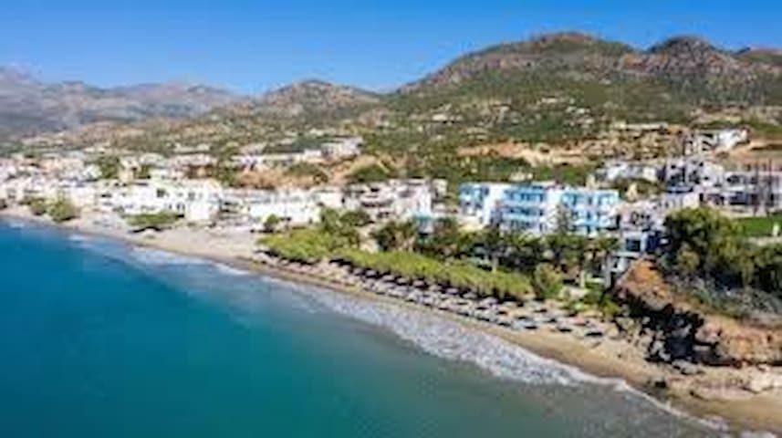
Makry Gialos is a famous seaside resort in southeast Crete, in Lassithi Prefecture. You may know it as Makrygialos or Makrigialos, though in recent years the locals have been attempting to establish the name Makry Gialos, because many people were confusing the village in southern Crete with another of the same name in northern Greece.
If you drive along the road through Makry Gialos from Ierapetra to Sitia, you may not be that impressed. You may think this is just another village not worth stopping for. But if you go a little further east, there is a unique view of the bay of Makry Gialos, revealing all the beauty of the village with its little harbour and large beach.
15 lokal ang nagrerekomenda
Paralia Makris Gialos
Makry Gialos is a famous seaside resort in southeast Crete, in Lassithi Prefecture. You may know it as Makrygialos or Makrigialos, though in recent years the locals have been attempting to establish the name Makry Gialos, because many people were confusing the village in southern Crete with another of the same name in northern Greece.
If you drive along the road through Makry Gialos from Ierapetra to Sitia, you may not be that impressed. You may think this is just another village not worth stopping for. But if you go a little further east, there is a unique view of the bay of Makry Gialos, revealing all the beauty of the village with its little harbour and large beach.
This beautiful beach is located 96 km east of the town of Agios Nikolaos and 2.5 km north of the palm forest of Vai.
Itanos beach, took its name from the ancient city of Itanos.
The crystal clear sea and the archeological site located in the area are the two main characteristics of the area.
Combine your swim on the beach, diving with a mask in its cool waters, since some parts of Ancient Itanos are located in the sea.
The beach is not organized, although most of the time there are enough people to enjoy the sun and its swimming there, in its light waters.
33 lokal ang nagrerekomenda
Erimoupolis Beach
This beautiful beach is located 96 km east of the town of Agios Nikolaos and 2.5 km north of the palm forest of Vai.
Itanos beach, took its name from the ancient city of Itanos.
The crystal clear sea and the archeological site located in the area are the two main characteristics of the area.
Combine your swim on the beach, diving with a mask in its cool waters, since some parts of Ancient Itanos are located in the sea.
The beach is not organized, although most of the time there are enough people to enjoy the sun and its swimming there, in its light waters.
Φαγητό
Is a port town and a municipality in Lasithi, Crete, Greece. The town has 9,912 inhabitants (2011) and the municipality has 18,318 (2011). It lies east of Agios Nikolaos and northeast of Ierapetra. Sitia port is on the Sea of Crete, part of the Aegean Sea[2] and is one of the economic centers of the Lasithi region. European route E75, which ends in Vardø, starts in Sitia. Sitia is served by the Sitia Public Airport. Sitia has not experienced the effects of mass tourism even though there is a long beach along the road leading to Vai and several places of historical interest.
71 lokal ang nagrerekomenda
Sitia
Is a port town and a municipality in Lasithi, Crete, Greece. The town has 9,912 inhabitants (2011) and the municipality has 18,318 (2011). It lies east of Agios Nikolaos and northeast of Ierapetra. Sitia port is on the Sea of Crete, part of the Aegean Sea[2] and is one of the economic centers of the Lasithi region. European route E75, which ends in Vardø, starts in Sitia. Sitia is served by the Sitia Public Airport. Sitia has not experienced the effects of mass tourism even though there is a long beach along the road leading to Vai and several places of historical interest.
Mochlos is a traditional village, located 48km east of Agios Nikolaos and 35km west of Sitia. It is situated 150m opposite the islet of St. Nicholas with the homonym chapel, which is a very important archaeological site. The village retains the traditional elements of Crete intact and is an ideal destination for relaxing holidays. The villagers, mostly originating from the village Sfaka, are very friendly and you will feel very familiar with them on the first day. If you're lucky, you might meet some of the events organized by the locals, such as fishing contests.
Along the coastal road of the village there are a few taverns and cafes where you can enjoy fresh seafood and your drinks; these taverns are famous even to Greek celebrities. There was an old tax office next to the taverns, which was unfortunately demolished several years ago. In front of the small village, you will find the small beach of Mochlos that is sandy and has rocky bottom. Next to it there are the basic amenities, but still it is not organized. If you head to the east, you will find the second bay of the village, which is smaller and rockier.
20 lokal ang nagrerekomenda
Mochlos
Mochlos is a traditional village, located 48km east of Agios Nikolaos and 35km west of Sitia. It is situated 150m opposite the islet of St. Nicholas with the homonym chapel, which is a very important archaeological site. The village retains the traditional elements of Crete intact and is an ideal destination for relaxing holidays. The villagers, mostly originating from the village Sfaka, are very friendly and you will feel very familiar with them on the first day. If you're lucky, you might meet some of the events organized by the locals, such as fishing contests.
Along the coastal road of the village there are a few taverns and cafes where you can enjoy fresh seafood and your drinks; these taverns are famous even to Greek celebrities. There was an old tax office next to the taverns, which was unfortunately demolished several years ago. In front of the small village, you will find the small beach of Mochlos that is sandy and has rocky bottom. Next to it there are the basic amenities, but still it is not organized. If you head to the east, you will find the second bay of the village, which is smaller and rockier.
City/town information
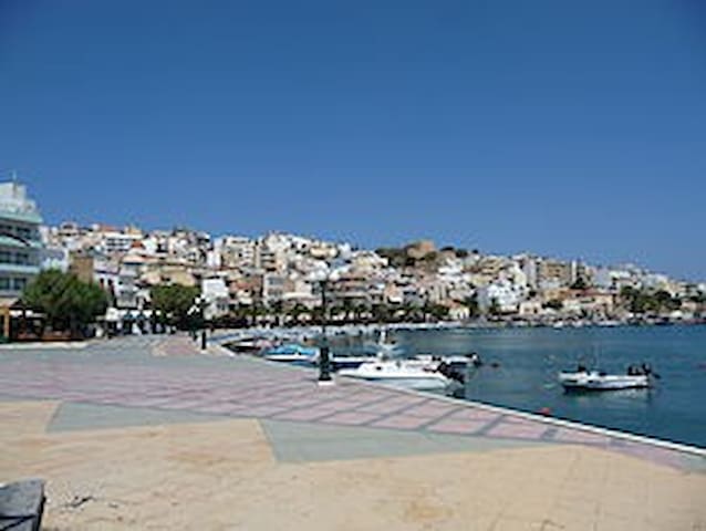
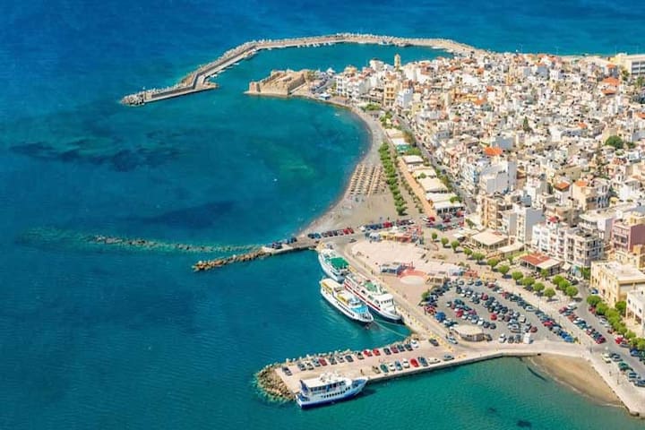
An international cosmopolitan seaside resort, attracting thousands of visitors every year. The lake, the town’s jewel, is known for its many legends, according to one of which, Athena and Artemis are bathing in its waters. The lake becomes one with the sea through a narrow canal, and is surrounded by red rock formations and lush vegetation.
A stroll in the shops is always a pleasure. Stores sell unique traditional Cretan art artifacts, copies from the local archaeological museums, jewels, and impressive embroidery. They also sell local products and delicacies that dazzle everyone’s palate. The town is filled with traditional coffee shops that serve local dishes and raki.
Agios Nikolaos is equally magical at night. There are numerous bars, with a relaxed atmosphere and loud music, that attract the younger crowds. The town of Agios Nikolaos is a beautiful place with open-hearted people!
140 lokal ang nagrerekomenda

Agios Nikolaos
An international cosmopolitan seaside resort, attracting thousands of visitors every year. The lake, the town’s jewel, is known for its many legends, according to one of which, Athena and Artemis are bathing in its waters. The lake becomes one with the sea through a narrow canal, and is surrounded by red rock formations and lush vegetation.
A stroll in the shops is always a pleasure. Stores sell unique traditional Cretan art artifacts, copies from the local archaeological museums, jewels, and impressive embroidery. They also sell local products and delicacies that dazzle everyone’s palate. The town is filled with traditional coffee shops that serve local dishes and raki.
Agios Nikolaos is equally magical at night. There are numerous bars, with a relaxed atmosphere and loud music, that attract the younger crowds. The town of Agios Nikolaos is a beautiful place with open-hearted people!
Ierapetra is known as a relaxing summer holiday spot, perfect for couples and families who are looking for relaxing beach holidays with great food, sandy beaches in town and along the coast and the 14th-century Fortress of Kales. Visitors to Ierapetra enjoy day trip options into the Cretan countryside and Chryssi island, around 9 nautical miles into the Libyan Sea.
68 lokal ang nagrerekomenda
Ierapetra
Ierapetra is known as a relaxing summer holiday spot, perfect for couples and families who are looking for relaxing beach holidays with great food, sandy beaches in town and along the coast and the 14th-century Fortress of Kales. Visitors to Ierapetra enjoy day trip options into the Cretan countryside and Chryssi island, around 9 nautical miles into the Libyan Sea.